Field Coordinates
Although the coordinates of points on a wellpath could be expressed as
UTM coordinates, it is not normal practice. Instead, a reference point on
the platform or rig is chosen as the local origin and given the coordinates
0,0. On offshore platforms this point is usually the center of the platform.
The Northings and Eastings points on the wells drilled from the platform
are referenced to this single origin. This is important when comparing
positions of wells, in particular for anti-collision analysis.
Direction Measurements
Survey tools measure the direction of the wellbore on the horizontal plane
with respect to North reference, whether it is True or Grid North. There are
two systems:
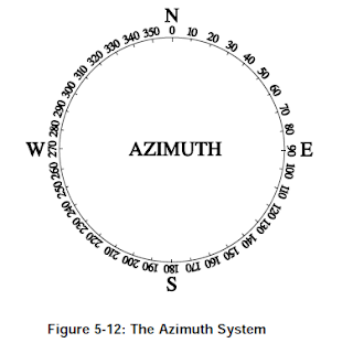
Azimuth.
In the azimuth system, directions are expressed as a clockwise angle from
0° to 359.99°, with North being 0°.

Quadrant Bearings
In the quadrant system , the directions are expressed as angles
from 0°-90° measured from North in the two Northern quadrants and from
South in the Southern quadrants. The diagram in Figure 5-14 illustrates
how to convert from the quadrant system to azimuth, and vice versa.

Although the coordinates of points on a wellpath could be expressed as
UTM coordinates, it is not normal practice. Instead, a reference point on
the platform or rig is chosen as the local origin and given the coordinates
0,0. On offshore platforms this point is usually the center of the platform.
The Northings and Eastings points on the wells drilled from the platform
are referenced to this single origin. This is important when comparing
positions of wells, in particular for anti-collision analysis.
Direction Measurements
Survey tools measure the direction of the wellbore on the horizontal plane
with respect to North reference, whether it is True or Grid North. There are
two systems:
Azimuth.
In the azimuth system, directions are expressed as a clockwise angle from
0° to 359.99°, with North being 0°.

Quadrant Bearings
In the quadrant system , the directions are expressed as angles
from 0°-90° measured from North in the two Northern quadrants and from
South in the Southern quadrants. The diagram in Figure 5-14 illustrates
how to convert from the quadrant system to azimuth, and vice versa.

No comments:
Post a Comment